Reference Document
Geography of the Kingdom of Boralani
Kingdom of Boralani — Royal Geographic and Hydrographic Survey Authority
National Geographic Profile — 2026 Edition
Overview
The Kingdom of Boralani is a small South Pacific island nation composed of volcanic high islands, reef systems, lagoon environments, and scattered outer island territories located within a strategically significant region of Oceania.
The geography of Boralani profoundly shapes:
- national identity,
- settlement patterns,
- political culture,
- transportation,
- economic policy,
- and maritime strategy.
Like many Pacific island states, Boralani possesses a relatively small landmass but controls an enormous surrounding maritime zone.
The kingdom’s geography is often summarized domestically by the phrase:
“Small land, vast sea.”
Geographic Setting
Region
Southwest Pacific Ocean
- East of the Solomon Islands
- Northeast of Vanuatu
- Northwest of Fiji
- South of Tuvalu
Geographic Classification
- Polynesian cultural sphere
- Mixed volcanic and coral island system
- Tropical maritime environment
Relative Position
Boralani lies:
- northeast of Fiji,
- southeast of Tuvalu,
- west of Samoa,
- and north of Tonga.
The kingdom occupies an important position along several regional maritime and aviation corridors linking Polynesia and the broader Pacific.
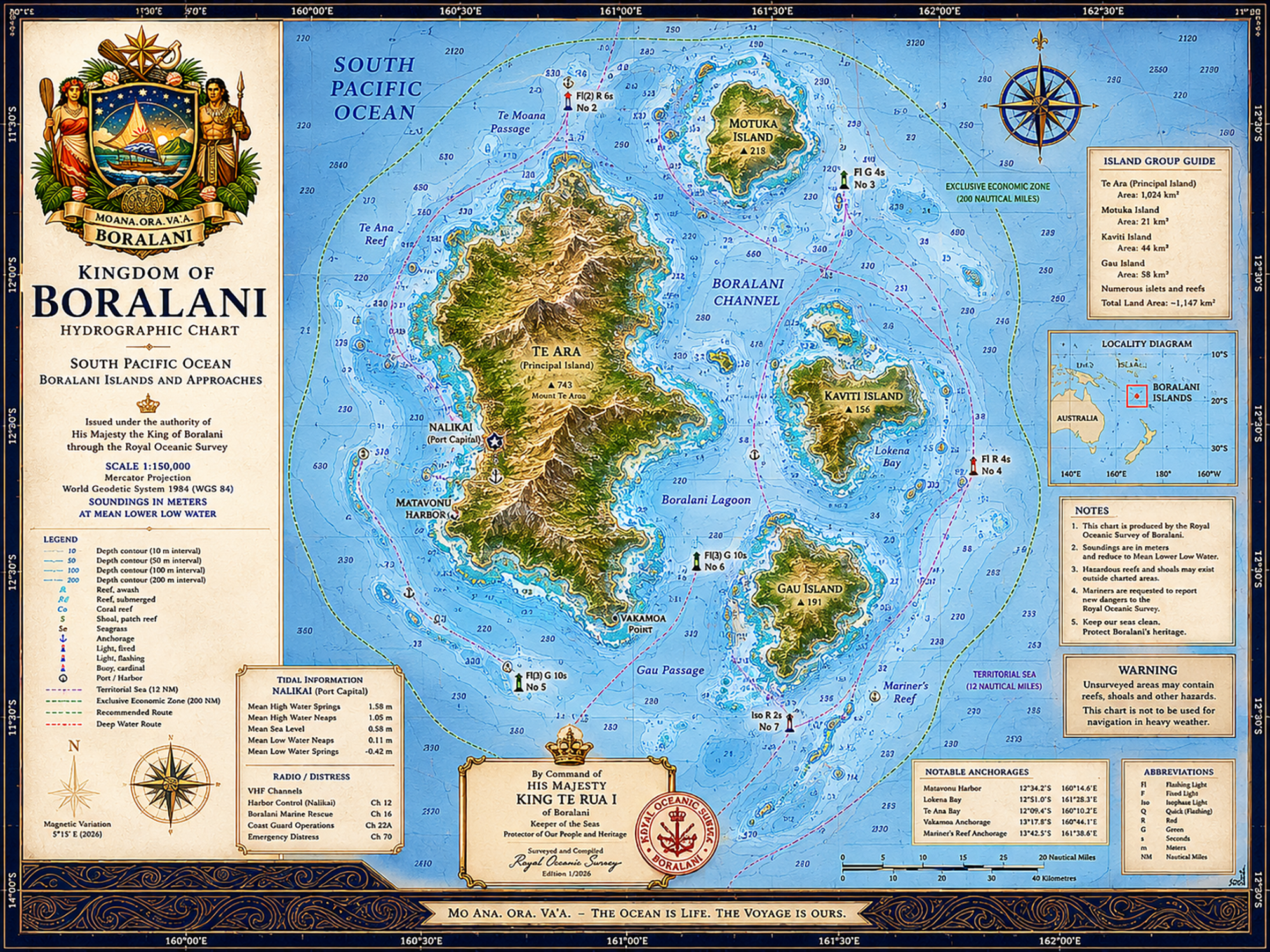
National Territory
Total Land Area
Approximately 1,940 square kilometers
Exclusive Economic Zone (EEZ)
Approximately 1.4 million square kilometers
As with many Pacific nations, the kingdom’s maritime territory vastly exceeds its land area.
The ocean is therefore regarded not as a boundary, but as the primary domain of national life.
Island Structure
The Kingdom of Boralani consists of:
- one principal volcanic island,
- several secondary inhabited islands,
- reef systems,
- outer maritime territories,
- and scattered low coral formations.
Principal Islands
Te Ara
Largest Island and National Core
Te Ara serves as:
- political center,
- population center,
- economic hub,
- and primary transportation nexus.
The island contains:
- Mount Te Ara,
- the capital city of Nalikai,
- major ports,
- agricultural valleys,
- and the kingdom’s principal infrastructure.
Geographic Characteristics
- volcanic mountain spine,
- steep interior terrain,
- dense tropical vegetation,
- black volcanic beaches in some coastal areas,
- and extensive reef systems.
Motuka Island
Located north of Te Ara, Motuka is known for:
- traditional fishing communities,
- whale migration waters,
- and relatively isolated settlements.
The island has retained more traditional social structures than the capital region.
Kaviti Island
Eastern island group characterized by:
- lagoons,
- shallow reef shelves,
- and calmer coastal waters.
Kaviti serves as an important inter-island ferry and fisheries support point.
Gau Island
Southern island territory near the Gau Passage.
Known for:
- rougher sea conditions,
- exposed cliffs,
- and important maritime approaches into southern Boralani waters.
Major Geographic Features
Mount Te Ara
Elevation: Approximately 2,180 meters
Dormant volcanic peak dominating the central island.
The mountain strongly influences:
- rainfall patterns,
- freshwater supply,
- and local climate variation.
Cloud forests occupy portions of the upper elevations.
Boralani Lagoon
Large protected lagoon system near Nalikai.
Functions as:
- harbor zone,
- fisheries nursery,
- and major transportation corridor.
Te Moana Passage
Deep-water maritime corridor used by:
- ferries,
- fisheries patrol vessels,
- and international shipping traffic.
Matavonu Harbor
Primary commercial harbor outside the capital.
Important for:
- cargo operations,
- fisheries logistics,
- and fuel storage.
Reef Systems
Coral reefs surround much of the kingdom and are considered central to:
- fisheries,
- coastal protection,
- biodiversity,
- and tourism.
Major reef systems include:
- Te Ana Reef,
- Mariner’s Reef,
- and the Vakamoa Shelf.
Climate
Climate Type
Tropical maritime climate
Characteristics
- warm temperatures year-round,
- high humidity,
- seasonal rainfall variation,
- and strong oceanic influence.
Average temperatures generally range between:
24°C to 31°C (75°F to 88°F)
Wet & Dry Seasons
Dry Season
May–October
Characterized by:
- lower humidity,
- calmer seas,
- and increased tourism activity.
Wet Season
November–April
Associated with:
- heavy rainfall,
- thunderstorms,
- tropical depressions,
- and cyclone risk.
Cyclones & Natural Hazards
Boralani lies within a cyclone-prone region of the South Pacific.
Major hazards include:
- tropical cyclones,
- storm surge,
- coastal flooding,
- landslides,
- and coral damage.
The kingdom maintains extensive:
- evacuation systems,
- cyclone shelters,
- and maritime emergency procedures.
Seismic & Tsunami Risk
Boralani exists near active tectonic zones associated with Pacific plate movement.
The kingdom maintains:
- tsunami siren systems,
- elevated evacuation routes,
- and regional seismic monitoring partnerships.
Public tsunami awareness education begins in primary school.
Freshwater Resources
Freshwater availability remains a critical national concern.
Sources include:
- mountain rainfall catchments,
- underground aquifers,
- rainwater storage systems,
- and limited desalination infrastructure.
Outer islands remain particularly vulnerable to drought conditions.
Biodiversity
Marine Biodiversity
Boralani waters contain:
- coral reef ecosystems,
- tuna migration corridors,
- sea turtle nesting areas,
- reef sharks,
- manta rays,
- and seasonal whale populations.
The kingdom actively enforces marine protected areas to preserve fisheries health.
Terrestrial Biodiversity
Native terrestrial species include:
- tropical seabirds,
- fruit bats,
- coastal forest species,
- and endemic plant life adapted to volcanic soils.
Introduced invasive species remain an ongoing environmental concern.
Land Use
Major Land Categories
| Land Use | Approximate Share |
|---|---|
| Forest & Natural Vegetation | 46% |
| Coastal Settlement | 18% |
| Agriculture | 16% |
| Protected Areas | 14% |
| Infrastructure & Industry | 6% |
Government policy strongly restricts uncontrolled coastal development.
Transportation Geography
Because of mountainous terrain and fragmented islands, maritime transport remains essential.
The national transportation system depends heavily upon:
- ferries,
- coastal cargo vessels,
- and small regional air connections.
Many communities remain accessible only by sea.
Maritime Geography
The geography of Boralani is fundamentally maritime rather than continental.
Government planners often describe the kingdom as:
“An ocean state with islands attached.”
National security, trade, communications, and food systems all depend upon uninterrupted maritime access.
Undersea Infrastructure
Boralani maintains:
- regional undersea cable connections,
- satellite backup systems,
- and coastal communications facilities.
Submarine cable protection has become an increasing national-security concern.
Environmental Policy
The kingdom places heavy emphasis on:
- mangrove preservation,
- reef conservation,
- fisheries sustainability,
- and coastal resilience.
Large-scale seabed mining proposals remain politically controversial.
Climate Change Vulnerabilities
Major long-term threats include:
- sea-level rise,
- coral bleaching,
- freshwater salinization,
- stronger cyclones,
- and coastal erosion.
Government adaptation policy increasingly focuses on:
- elevated infrastructure,
- seawall reinforcement,
- and strategic retreat from vulnerable coastlines.
Protected Areas
The kingdom maintains both:
- terrestrial conservation zones,
- and marine protected areas.
Several reef systems are seasonally closed to fishing to preserve spawning cycles.
Traditional community stewardship systems remain integrated into conservation policy.
Geographic Influence on National Identity
The people of Boralani traditionally view geography not as scenery, but as obligation.
Mountains provide water.
Reefs provide food.
Lagoons provide shelter.
The sea provides connection.
As a result, environmental stewardship carries unusually strong cultural and political significance throughout the kingdom.
National Geographic Character
Foreign observers frequently describe Boralani as:
- geographically dramatic,
- maritime-centered,
- environmentally disciplined,
- and unusually protective of its coastal identity.
Despite modernization, much of the kingdom still operates according to rhythms imposed by:
- tides,
- trade winds,
- rainfall,
- and the open Pacific itself.
In Boralani, geography is not background.
It is destiny.